


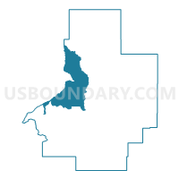
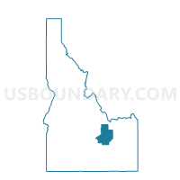
Moore Voting District, Butte County, Idaho
About
Outline

Summary
| Unique Area Identifier | 563899 |
| Name | Moore Voting District |
| County | Butte County |
| State | Idaho |
| Area (square miles) | 189.02 |
| Land Area (square miles) | 188.72 |
| Water Area (square miles) | 0.31 |
| % of Land Area | 99.84 |
| % of Water Area | 0.16 |
| Latitude of the Internal Point | 43.78886480 |
| Longtitude of the Internal Point | -113.38536230 |
Maps

Graphs
Select a template below for downloading or customizing gragh for Moore Voting District, Butte County, Idaho


Neighbors
Neighoring Voting District (by Name) Neighboring Voting District on the Map
- Arco 1 Voting District, Butte County, ID
- Arco 2 Voting District, Butte County, ID
- Howe Voting District, Butte County, ID
- Leslie Voting District, Custer County, ID
Top 10 Neighboring County Subdivision (by Population) Neighboring County Subdivision on the Map
- Arco CCD, Butte County, ID (2,533)
- Mackay CCD, Custer County, ID (1,421)
- Howe CCD, Butte County, ID (358)